Maps can be so deceiving!
Last week I completely fell for information I took from several maps. I was in Argentina briefly because my 90 days in Chile were coming to an end and I had to leave the country. With no clear destination (other than coming back to Chile) I spent most of the time around Uspallata, a tourist town in the Andes. The weather was beautiful and warm and the scenery around Uspallata quite stunning. I only had to do go to Mendoza to do some shopping (many things are cheaper in Argentina with the Dolar Blue exchange ).
To get to Mendoza I took the busy Ruta 7, the same way I had driven to Chile in May; to return to Uspallata I decided to take a different route, Ruta 52, marked on my Reise-Know-How maps as a scenic route.

Reise-Know-How paper map Mendoza to Uspallata
Next day I went searching for a supermarket. I first checked my navigation app, Skobbler, which has all sorts of ‘points of interest’ in its database, but it wanted to send me into the town center – not a good idea with a truck, because supermarkets in Latin America often only have enclosed parking. Since I knew that I wanted to leave town along Ruta 52, I marked a spot at the start of it as my next destination in the hope I would find a supermarket along the way. Despite extensive searching up and down some main streets I had no luck, so I finally asked somebody in front of a bakery, who sent me back up the hill to where I had come from. Long story short: I wasted at least one and a half hours searching and ended up at a Walmart – not my preferred choice…

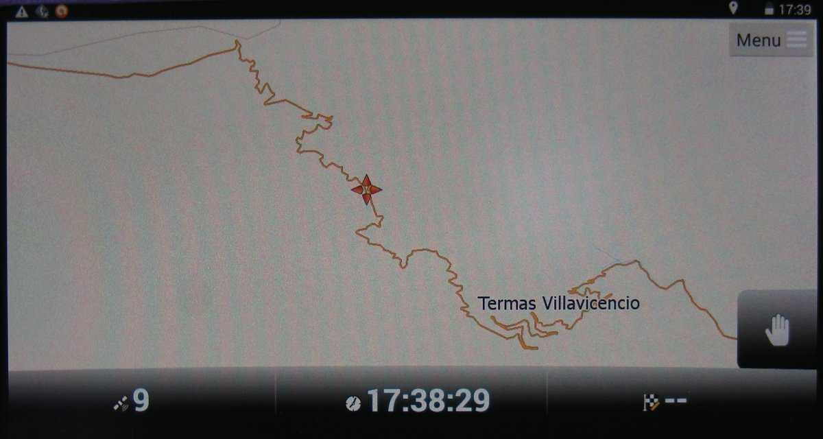
Ruta 7 or 52 – displayed on Skobbler GPS map
Deceived by my paper map and my GPS map
I finally left at around 2pm, ready to drive back to Uspallata. This is where I was completely led astray by all maps I have access to: it should have been easy, as it is only a bit over 100 kilometers and I was already in the North of Mendoza where the road begins.
It started rather well: I found Ruta 52, there was little traffic, and the road was made from small, rather bumpy, concrete sections, so I took it slowly and crawled at around 60-70 km/h up a gentle rise, enjoying the sunshine, and thinking “why should I hurry?”.
I had been behind the wheel a lot in recent days, so I was in the mood to stop early, have some rest, and drive the remainder the next day. Unfortunately there wasn’t anything really attractive either side of the road. The landscape was almost flat, with mountains in the distance, and covered fairly densely with low dry scrub. Most of it was also fenced, with no roads going off left or right.
After about 40 minutes, just when I reached the foot of the first hill, I noticed a small gravel patch to the left. I stopped and inspected it but didn’t like it very much because I could only get 10 meters off the road and would be very exposed. It was still early, and I thought there should be something better and cosier ahead in the hills… What a mistake!

Bing Map: route choices Mendoza to Uspallata; Google maps has a section of 52 missing right outside Mendoza…
You see, from all the information I had, the drive should take around 2 to 3 hours. On maps I had looked at there were no major zigzag lines marked (less than on Ruta 7 to the South), so I expected the road would mostly follow valleys between the mountains, or something like that – easy to drive.
Then the bumpy concrete changed to relatively narrow tar and the incline got steeper. I had to change gears up and down and I encountered a few fairly wide but sharp bends, but nothing major – after all, these are the Andes, so it can’t all be flat. Then it slowly got even steeper and for several sharper bends I had to go another gear down until finally, I didn’t get out of third gear anymore (Berta has five gears). I was in a narrow valley where the sun didn’t penetrate, but still nothing out of the ordinary…
I passed something which looked like a Ranger’s station to my right, but didn’t stop since I was only passing through and my Spanish isn’t that brilliant. And there the tar stopped – turned into gravel. Then I reached the first really narrow hairpin, then a second, then a large gate to a closed hotel in the third. The road got steeper; second gear now. The surface was not all gravel; large sections were bumpy blasted rock surface with corrugations in between. Soon I was almost always in second gear, going maybe 10-15 kilometers an hour, and even slower around the hairpin bends. Sometimes they came one after another, sometimes there was a straight bit in between tempting me to try third gear at around 20-25 km/h – but it never lasted very long.
The first stretch of gravel after the park entrance. The old hotel can be seen in the bottom left corner.
Initially I was enjoying it until, at one point, I looked up and noticed that this would go on for quite a way. Plus the road was now getting very narrow for long sections, sometimes for well over 100 meters including one or two hairpins. So, full concentration, stay away from the edge, look out for possible oncoming vehicles, blow your horn before every blind bend, search for spots where one could pass you, keep both eyes on the road to look out for sharp rocks and deep holes – slowly the nice drive turned into a bit of stress.
And, if that wasn’t enough, I was basically driving west, the sun was slowly setting, long sections of the road were already in shade but, every second or third corner I came around, I was suddenly blinded by the low sun hitting the dusty windshield and my eyes. Then the road became so narrow, partly due to some small landslides, that I could hardly get past rocks on the hillside any more. Please don’t let a crazy Argentinian come racing around the next bend, unable to stop in time on this loose and slippery surface! I tried to stop once and take a photo but the road was so steep it felt like either the parking brake wouldn’t really hold the truck or the wheels were sliding on the loose gravel underneath back down the incline.
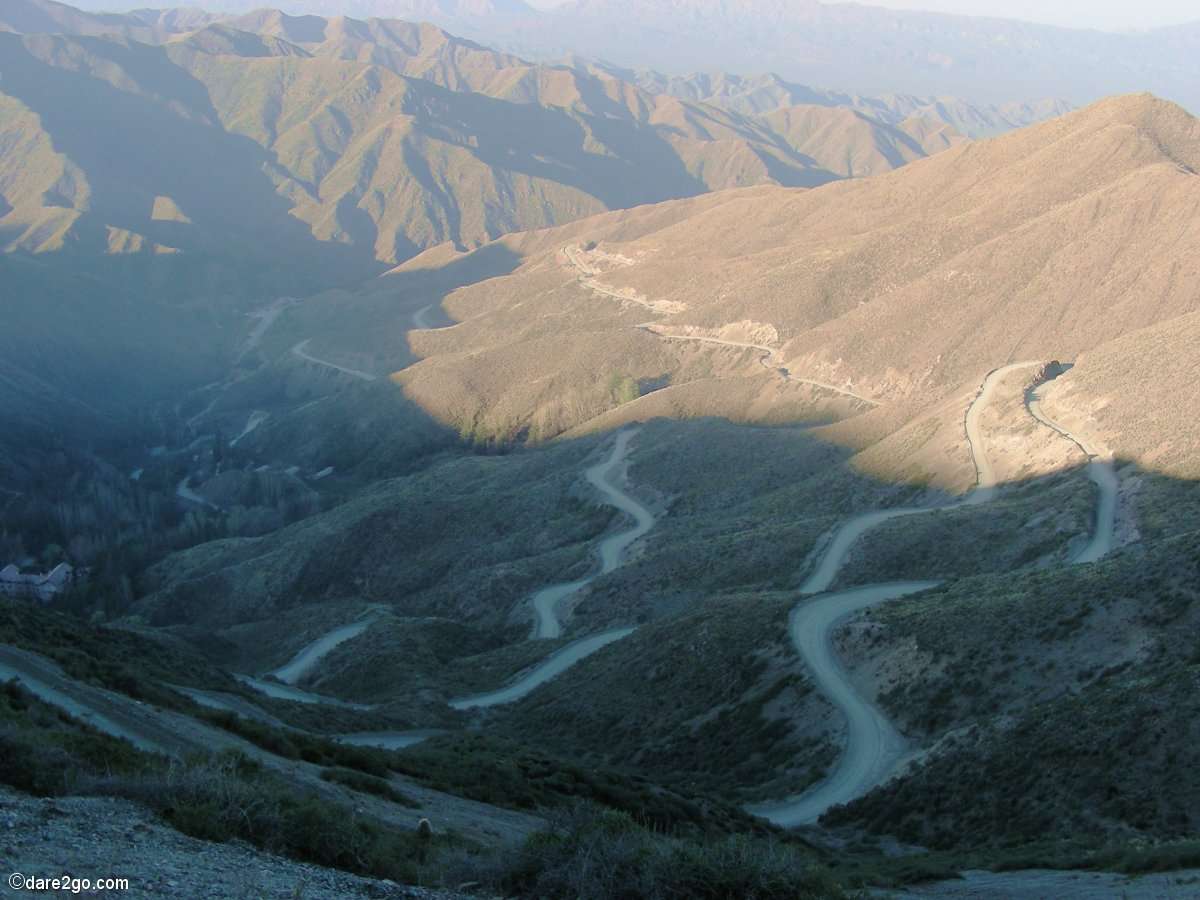
The Death Road of Argentina
GPS Navigator: the “curvy” section in close-up.
It was hairy and I was getting more stressed, not least because I noticed how slow my progress was and how low the sun was in the sky. If you don’t find a sleeping place in daylight the chances of finding one are drastically reduced. Where would I find a level spot to get off this narrow track, with upright cliff face to my left and several 100 meters falling steeply down on my right? Once you have reached a certain height on this road this is what it feels like! No more real switchbacks, only 60 to 90 degree corners, often very narrow, and you’re still climbing, up and up…
In my mind formed the thought “this is the death road of Argentina” (for all of you who have heard of the infamous Death Road in Bolivia , which is now only a tourist attraction, replaced by a new road for all other traffic). My mouth felt dry and I didn’t want to let go of the steering wheel to reach for my water bottle.
It’s probably not all that dangerous but with a truck the size of Berta you really don’t have much room, and in the past I’ve had a number of near misses with impatient macho Argentinian drivers – and who knows who might be coming head on around the next bend? As it was, I met maybe 10 vehicles the entire way, most of which I spotted well in advance. There were two I met just after getting around a hairpin but the road there was wide enough.
I still highly recommend this drive
Seriously: I would recommend this drive to anybody who is going from Mendoza to Chile. The alternative Ruta 7 is the one all trucks take towards the border with Chile – you’ll be sharing enough of it with them from Uspallata on. Take your time and leave Mendoza early in the morning. The steep side going up is facing east, so you can see the landscape much better; when I was going up almost everything below me was already plunged into shadow. Check conditions ahead of time! You don’t want to drive it in deep snow, after heavy rain or at the end of snow melt, because the western side of Ruta 52 basically runs along a river bed, the road is criss-crossed by badens (we call then floodways in Australia). If you have a large vehicle I would recommend avoiding weekends and holidays as traffic might drastically increase.

Vicuñas grazing in sunrise
Almost all vehicles I met were normal cars, from a tiny Suzuki hatchback to a Nissan pick-up, plus two Mercedes Sprinter tourist vans. With a few fairly brief stops it took me around 5½ – 6 hours to complete the drive. Despite my description, you can actually find a number of spots to halt (not for long, but to get out and take some photos) on the way uphill – I was running out of time and light towards the end of my day. I encountered the first place to spend the night at 2,600 meters – it was a level place enclosed by a hairpin bend; by then I was almost at the top where the landscape was comparatively flat. In the morning I was woken by herd of vicuñas grazing just across the road from me…
The scenery is stunning: on a clear day the vistas towards Mendoza and beyond would be amazing (unfortunately I had a thick layer of smog towards the east). You can see plenty of wild life like vicuñas and condors. At the ranger stations they promise pumas in these parts of the mountains, but the only other animals I noticed were a snake and a rock-climbing rabbit…
Don’t miss the “Balcon Del Inca”, a steep, narrow canyon with a viewing platform above. It’s badly sign-posted, the only sign being right at the “balcon” rather than on the road, but the track to it is fairly wide. There are road signs on either side of the road showing distances to Uspallata and Pte De Inca one direction and Villavicencio and Mendoza in the other. As this is possibly the only place you will find signs for both directions, they serve as a good marker.
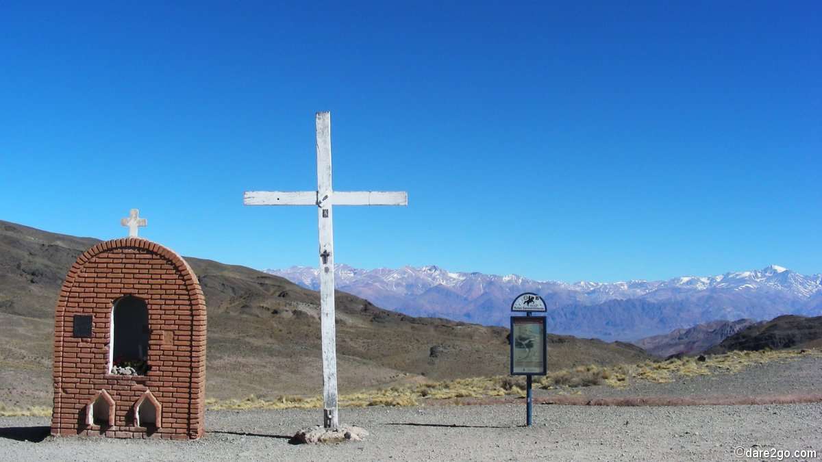
Cruz Del Paramillo at 2,960 meters
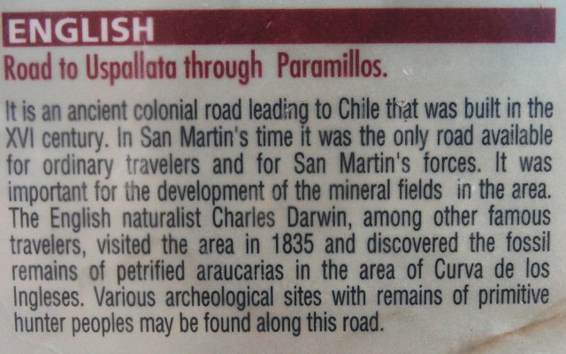
From Cruz Del Paramillo, 4 kilometers further along at almost 3,000 meters, it’s all downhill – but first stop to enjoy the view! You will come past the abandoned Minas de Paramillos , now turned into a museum (closed when I passed), and a large granite plaque commemorating Darwin’s discovery of some pre-historic skeletons in this region. No more sharp hairpins either, the road is mostly wide and just gently going downhill – unfortunately with plenty of corrugations…
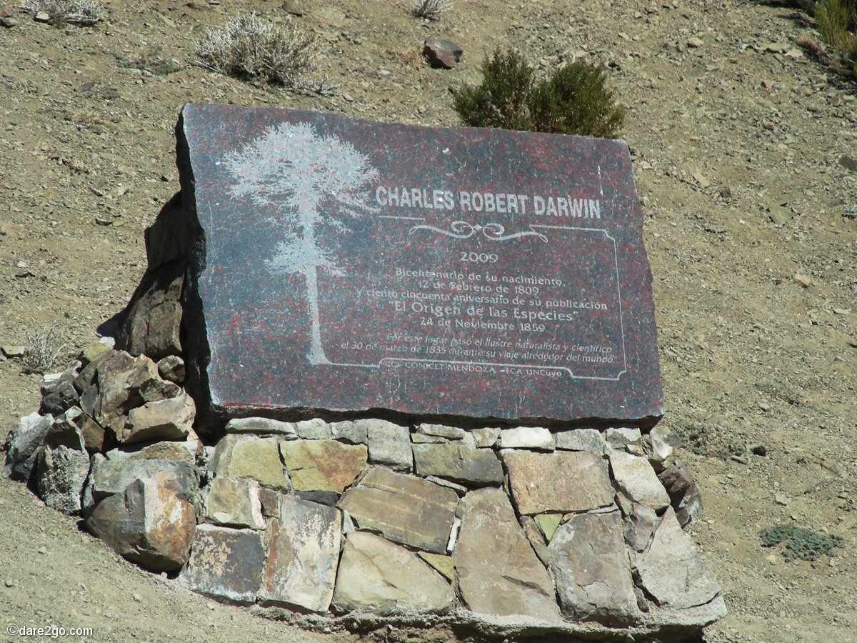
plaque commemorating Darwin
Amazing engineering
Historical facts about the Rutas Sanmartinianas
This is a road with a long history, dating back to the 16th century and Spanish conquistadores, but before that it was a track used by the Incas to cross the mountains. Darwin travelled this road too and there are a number of plaques commemorating him. Before Ruta 7 was re-routed to the south, this used to be the only connection between Mendoza and Uspallata. The road starts at roughly 800 meters in Mendoza, goes up to almost 3,000 meters, and reaches Uspallata at 1,900 meters. Reportedly there are 365 curves along the way – I didn’t count them!
If you would like to see an bird’s eye view of the road please follow this link ,
switch to “Full Screen” and zoom in.
UPDATE: we have added an extra gallery to show more photos of this beautiful region.
Further reading:
Footprint Guide online – Mendoza to Uspallata
Wikipedia on General San Martin
Wikipedia SPANISH: Rutas sanmartinianas
Have you driven this road? Maybe even under different conditions?
We would like to read your “comments” – please post below!
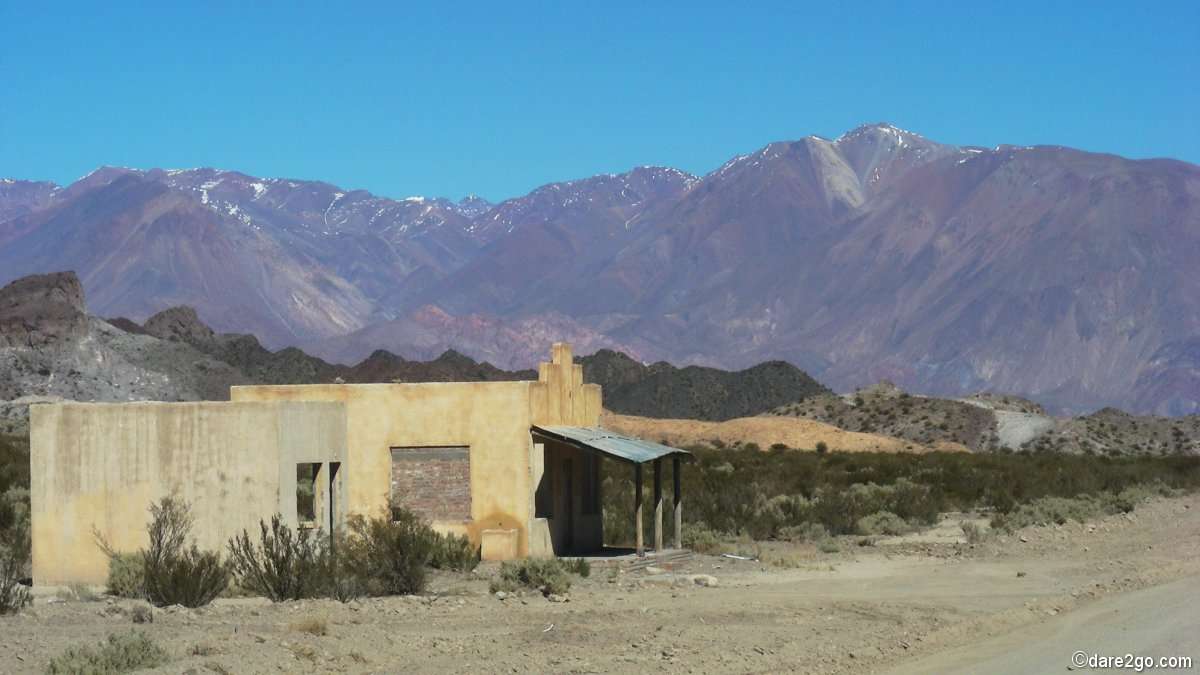
Close to Uspallata, long abandoned shop or road house


Isn’t this sort of experience why we are bumming around here instead of sitting home on the back patio waiting for the grim reaper to call.
You’re right! I also hope that my post made it clear that I thoroughly enjoyed the region around Uspallata – only the stress that one evening I could have done without…
Yep, I agree with some of the others … go once and tick it off! I would have needed a tranquiliser! I’ve done a few sort of similar drives on mountain passes in Lesotho … as you say, a map can’t always be trusted.
I’m still not sure if we shouldn’t return, as my lovely wife Yasha wasn’t with me this time (she had to stay behind in Santiago). Time will tell!
Love drives like this. Grew up driving jeeps up and down the old mining and logging roads in Colorado. It can get a bit hair raising, more than once I had a wheel hanging in mid air off the road.
I would want to have that happen with our truck (wheel hanging in the air), which is also our home! The high point of gravity alone makes this a scary prospect…
What an incredible adventure! Your photos are amazing. I never dare drive in other countries (I don’t even like to at home), but I’d love to see what you did on this drive.
WOW; I’m glad you made it OK and didn’t meet any crazy drivers! I really enjoyed following along as you were shifting gears and white-knuckling your steering wheel!!
What an exciting drive. But I can feel your anxiety the more I read. I think it’s not knowing how it’s all going to end or work out that is the biggest stress but what scenery!
That exactly was my main reason to be anxious! That’s why I recommend to leave Mendoza early and take it slowly, which would remove the main pressure and make the drive much more enjoyable…
Yes, maps can be deceiving. I have a few stories, too! But the upside of your experience is that you have turned it into a blog post and now others can be forewarned and perhaps enjoy the same journey. :)
Getting lost can be fun . . . until it isn’t. If it’s any consolation, there are lots of blind spots on the mainland US and on our island of Kawai. Not fun when you’re trying to find a destination by a certain period of time.
My wife’s answer to getting lost is usually “we’re not lost, we have nowhere to be…”
Looks like a good place to go only once, cross off the list and enjoy the photos to keep you from returning. How people traveled these roads without a worry is amazing to me. We’ve driven the Miracle Mile in Colorado and considered it a miracle that we got to the end, but then had to drive it again to return to our motel.
I would have needed medication just to be a passenger on this road. When we visited Mendoza, we flew from there to Santiago. The flight doesn’t go up and over the Andes as much as through them. That was scary enough for me.
I’d think that as a passenger this road can be more of a challenge. You’re not in control of the vehicle, you are sitting for most of the trip on the side where the edge plunges down for several hundred meters, you will concentrate more on the washed out edges and other obstacles ahead… My wife is not sure either if we should repeat this journey with her in the passenger seat ;)
Brilliant views but I was holding my breath just reading about the high altitude hairpin turns! Glad you arrived safely.