New Review of off-line Android GPS Navigation Apps
We have now been on the road full-time since 2014. So I think that writing a new post about our navigation with an Android tablet instead of a dedicated GPS device is overdue.
What you will find in this article:
This is my review of off-line Android navigation apps – from real experience!
In late 2014 I introduced and reviewed my two favourite apps in 3 lengthy posts.
A lot has happened since then. We have driven almost 35,000 kilometres, all of them in South America, and are now in our fourth country. We have navigated all of this with the tablet running on the dashboard of Berta , giving me directions.
Of course, using an Android phone or tablet for navigation requires that you have enough power to keep the device always ‘on‘. No problem in a vehicle, where you can either plug into the old-fashioned cigarette lighter or use a pre-installed USB-port. If you are looking to use the same device whilst hiking or biking you might want to consider dedicated GPS devices with better battery life .

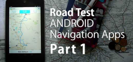
Our follow-up review of Android off-line navigation apps after 35,000 kilometres on the road. It includes 5 apps, some of which we dismissed outright.
Off-line Android GPS Navigation Apps I have tried
MapFactor Navigator, my second favourite app, has gone through numerous updates since my last review. Recently it introduced a number of premium (meaning: you pay for them) add-ons. We bought one of them, which gives the option to choose from three suggested routes. There’s a second one which is supposed to provide an overhead display (onto the windscreen, which I can’t see any use for). The third add-on removes all advertising from the app (we are off-line 95% of the time so we don’t get ads anyhow).
On the other hand, not much has happened with Skobbler/Scout at all! The app stopped providing map updates (at least for South America) sometime in early 2015 and my complaints on their support forum remain unanswered. Despite all that, I’m still using Skobbler most of the time – more about my reasons for doing so later…
Initially I didn’t care that much about the missing map updates from Skobbler. That was until we came to Brazil the first time in October 2015. Suddenly I realised that not only were road changes missing, but in some instances over half the roads in some towns were not part of the map at all.
All really usable maps for South America come from the Open Source database. It’s then up to individual developers how they use the OSM (Open Street Map) data to render into maps for their applications. Hence the base data for all navigation apps should be identical, providing that app developers don’t fall behind with converting the information into their map format. But falling behind is what seems to happen with quite a few of them; this is probably because the expectation of quick riches wasn’t fulfilled soon enough…
At the time that I discovered the mapping issues with Skobbler, my other app (Navigator) was only providing a single possible route. The Navigator route almost always showed preference for major highways – exactly the roads we like to avoid.
So I thought I was in urgent need of a replacement for Skobbler. But there aren’t many apps which give the user a choice of several routes, so my options were narrowed down quickly!

Skobbler offers always 3 route choices. But, sometimes the differences are minimal; at other times I would love to combine part of one route suggestion with a part of another.
Here are some apps I tried, some of which I still have on my tablet.
Please find all download links at the bottom of this article!
OsmAnd Navigation App
Several fellow Pan-Am overlanders swear by it. In theory it should have a key advantage: the maps are layered vector graphics, which need less storage and should make the app faster – but not the way I often like to use the app.
For example: When we’re looking for alternative routes or overnight sleeping places I like to scroll through the map on my tablet; zoom in and out until I get a clear picture of where I am and what is around me. In OsmAnd this is nearly impossible because every time you move the map only slightly it wants to redraw the entire map. So you wait – and wait some more. The need of the vector maps to redraw every time makes it slower than stored map images.
Also, I found OsmAnd gives way too many instructions and there is no setting to adjust this. What use is it if I am told that I have to turn in 4 kilometres (then 2, then 1, then 500 metres, then 200 metres) when I’m crawling along a bumpy dirt track? It can be up the 30 minutes before I have finally covered the 4 kilometres from the first announcement. These are only distractions!
I have since deleted OsmAnd. I found the slow re-rendering of vector maps just too frustrating. It’s been a while since I used it, so I can’t remember if it even offers multiple routing options. I don’t think so.
Maps.Me Off-Line GPS

Maps.Me: here the routing to the next big supermarket. Blue dots along the way mark other supermarkets found by Maps.Me.
Another off-line navigation app praised by many. Their maps are very detailed and contain tons of POIs (Points of Interest), mostly business listings (that they make money from?). The search for particular business types often works surprisingly well since, for example, you can tap ‘Shop’ and then type ‘Supermarket’ behind – it then only lists supermarkets.
To their credit I have to say that Maps.Me also contains a lot of tourist sites. Unfortunately, these are often named very vaguely, so you can have 10 ‘peaks’ or 5 ‘cascadas’ within a radius of ten kilometres. Which one of them is really worth going to?
There are 3 main reasons why I don’t open Maps.Me much.
Below are 3 reasons why I didn’t use Maps.Me much. By now [2019] I have completely uninstalled it (for more please scroll down)
First: it only gives one route, also mostly following main roads. In fact, I have never driven anywhere with Maps.Me running as my navigation app.
Secondly: Maps.Me is really slow. A ‘search’ for POIs takes ages, and calculating a route is so slow that I often think the app has crashed. That’s most likely due to its comprehensive database. And still, it doesn’t know about many one-way streets.
The final reason: I find it nearly impossible to scroll through the maps of Maps.Me. One moment the map moves according to my finger movements, and the next it suddenly jumps a long distance away (often moving the focus 100-200 kilometres from where I was looking).
Catch 22: if I used it more often, maybe I would get a better feel for it, but since it annoys me so much I don’t use it very often.
[Update 2019] I’ve uninstalled Maps.Me completely! Why? The catch of free Android Apps: they need/want to make money one way or the other. Maps.Me is a Dutch company and uses Booking.com, another Dutch company, for affiliate income by recommending hotels. I never had a problem with this until they started to show every possible hotel and restaurant on their maps – something you can’t suppress. The final annoyance with this happened in Barcelona, where we used it to walk in the city. We were particularly interested in the Gaudi architecture of Barcelona . Near the main street, The Rambla, is one Gaudi building called “Palau Guell”. I found it on Maps.Me, but try as I might, I never got the app to display all side street names in this part of the city! The simple reason was, that all available space on the map was taken up by hotel symbols and names. Yet, when I go somewhere I want to know the names of side streets so that I get a better sense of distance.
Attention: Maps.Me doesn’t uninstall cleanly either! You have to go into the file structure of your Android device to delete all map data and other stuff manually, otherwise it will use up storage you might need for other things. Another annoyance!
Magic Earth

Disappointing (or plainly wrong) routing suggestions make Magic Earth fairly unusable.
A fellow (frustrated Skobbler) user recommended Magic Earth to me on the Skobbler support forum. It’s one of the few apps which also calculates up to 3 different route options. In a way it can calculate even more because, after having entered your destination, it first asks if you want to walk, cycle, or drive the ‘shortest route’ (1 option only), or if you want to drive the ‘fastest route’ (where it calculates up to 3 options).
Sadly, in practise I found that it seems to have too many routing faults – more than I have ever experienced with Skobbler! This might only be the case in South America and the app might work well in USA and Europe – but South America is where I am!
Also, I haven’t found a decent, clear voice for it yet. And finally, I don’t like how POIs are sorted within the database very much. We use our navigation app frequently to find a supermarket in a town we don’t know – it’s of no help if all shops are mixed together under the ‘shopping’ category.
Where we are staying now, there’s a small supermarket at the end of the road and another one 1.4 kilometres away. Skobbler knows of both under the rubric ‘Supermarket’ – easy (despite an outdated database). Magic Earth lists the nearest 4.3 kilometres away but in between there are 3 others (not in Magic Earth’s database)…
Magic Earth might do its ‘magic’ in Europe or the USA – in South America it seems nearly useless.
My top choices: Skobbler/Scout versus MapFactor Navigator
Back to my initial 2 choices for off-line navigation
As you can see, I’m open to suggestions for a suitable navigation app – but nothing has really come up yet! All the alternatives I have tried are more frustrating than my current life with incomplete Skobbler data.
Apart from the occasional hiccup, Skobbler/Scout usually gets me where I want to go. Some errors are caused from road sections missing in the app data, others from missing information about one-way streets.
A really frustrating thing I have experienced several times is that when I can’t follow Skobbler’s directions (for one reason or another like a closed road, no left turn permitted, a bridge too narrow, an overpass too low, etc.) it often recalculates the route and goes back to an option I had dismissed at the beginning! I don’t even get a notification about this!

Navigator (shown on Android phone screen) now offers up to 3 different routes – but only if it makes sense.
So now we have installed MapFactor Navigator on Yasha’s Android phone. I drive according to Skobbler and Yasha cross-checks the route in Navigator.
Our second reason for doing this was that I cannot install iOverlander on my tablet (wrong Android version)so we only have this on Yasha’s phone. Conveniently, iOverlander sends any waypoint straight to Navigator, where you can navigate to it.
The main reasons for Yasha having a back-up navigation app were mentioned at the end of Part 3 of my Road Test Navigation Apps on Android . Sometimes the apps make mistakes in cloverleaf intersections, or occasionally the voice announcements are so badly timed that I make mistakes in complicated highway intersections…
You probably know these instructions: “Turn Right” 100 metres too early… You have no time to verify on screen – and turn onto a ramp going in the wrong direction! Grrr.
Another thing I have to repeat as a strong criticism is the zoom level of the maps. That’s all maps of all apps! It happens way too often that I really would like to know the layout of a highway intersection much earlier than it is displayed on screen – particularly since none of the apps has a lane guidance feature with OSM maps.
Now that Yasha has a back-up app on her phone she can provide missing information verbally – if she has time. An added advantage is that we now have an off-line navigation app at hand when we walk through cities or use public transport. So not all of our excursions rely solely on my sense of direction. LOL.
Finally, I can show you some screen photos, which should explain why I’m still using Skobbler/Scout – despite all the niggles. [Sorry, I find it nearly impossible to take screen captures on my Nexus.] These are route suggestions from our current location to Ubatuba, a town on the coast of São Paulo state. We came up from there so we know some of the roads. Let me tell you that we often get better results for medium distances, something under 200 kilometres.
[ Click thumbnails for larger image ]
-
- From São João to Ubatuba: in this particular instance I would take the route suggested by Maps.Me. It’s the third shortest (only 11 kilometres difference to the shortest) and by-passes all of Rio de Janeiro’s city congestions and stress.

-
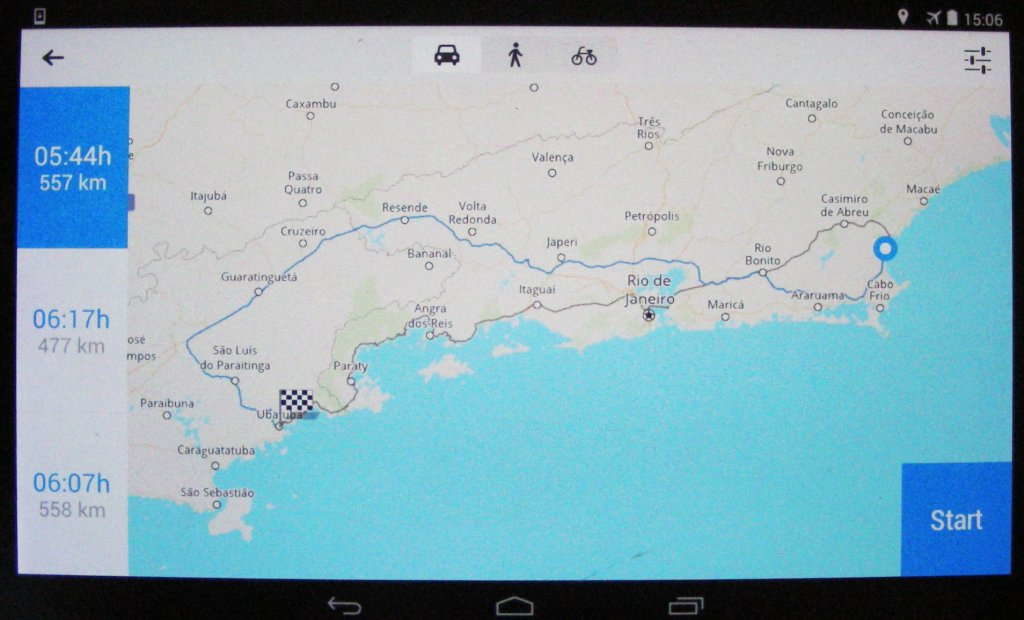
- From São João to Ubatuba: the 3 routing options given by Navigator. A cross check with another map revealed that the green route back to the coast is very windy, the one further east seems easier and faster.

-
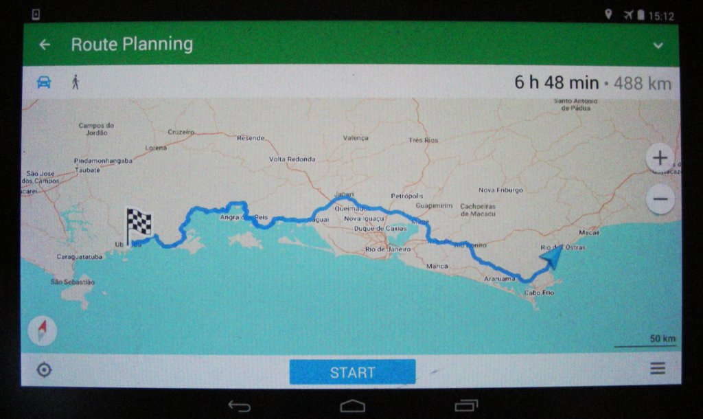
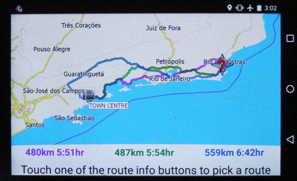
- From São João to Ubatuba: in this case Skobbler comes up with 2 routes which are too long and therefore not economical. The shortest goes right through Rio de Janeiro (and its traffic jams).

-

- From São João to Ubatuba: a complete fail for Magic Earth. Just compare with the route suggestions of all other apps. This is supposed to be the FAST route and the time given is three times as long as in all other apps! No other options were given.

-

- From São João to Ubatuba: this is the supposedly short route – almost twice as long as the one given by competitors.

I would probably take the route suggested by Maps.Me, which seems more suitable than the green marked route on MapFactor Navigator. Both go some distance around the urban mess of Rio de Janeiro, thus avoiding some congestion. Road tolls will probably be excessive; outside densely populated regions we usually like to avoid these.
But the foremost reason that I still use Skobbler is the ease with which I can scroll through maps, tap on a place, and activate a navigation to this place straight away… Until now, no other app has proven to be a worthwhile replacement for Skobbler/Scout! But I still keep keep swearing about it…
Do you know of any reliable off-line GPS navigation app for Android?
Is there one app you can truly recommend?
An app which offers at least routing alternatives and easy map scrolling?
I would really love to hear about it in the ‘comments’ below!

Download links in Google Play Store for all reviewed navigation apps:
MapFactor Navigator | Skobbler/Scout | OsmAnd | Maps.Me | Magic Earth


Hi Juergen,
thanks for a great post and comparison!
I also use Mapfactor Navigator and regarding what you mention at the end… you can also tap into the map in Navigator and directly navigate there. I often use this, because it is faster for me sometimes to set the destination from the map then to search for it. When you tap on the map a toolbar displays on the bottom of the screen with offer of “navigate”, “set start/destination” etc. Give it a try ;-).
I also like that during navigation I can switch between 3 types of view anytime – the 3D navigation mode, 2D (where I can easily move in the map and zoom out/in anywhere on the route or elswhere), and especially overview of the whole route. I always check the calculated route before starting the trip to be sure I am led to the right place.
Wish you further great travels! Katka
In the meantime Navigator has improved a fair bit (except their base map layout, which I still don’t like), whereas Skobbler is dead in the water for several years – sorely missed by me!
Hi, have you tried Here (we go). Offers offline line map storage, multiple route options etc and all free.
Yes, I had tried HERE at some time. I know it’s based on the old Nokia navigation, which was known to be very precise. To be honest, by now I cannot recall why I didn’t like it but there was something…
…Ha! That’s easy… the desire to try out something NEW! Enjoy Your travels!
thanks for the review. I found your site via Karin Marijke and Coen.
I did test a lot of android and iphone apps but I switched back to the new Garmin Overlander. I must say I am pretty happy with it. A review is posted on our blog.
Hi Jurgen,
Thank you very much for this information. Very useful.
We are Gé and Mariëtte Weisscher from the Netherlands (both 70 years old).In october/november 2018 we want to drive with a rental camper from Copiapo to Tinogasta in Argentina. We have some questions about this trip.
-Are there petrolstations on this route?
-How is the road? Good ripio, bad ripio, asphalt?
-Is this time good for traveling there?
-May be you can give us more useful tips/suggestions for driving this route.
Thank you very much in advance for your answer.
Greetings from the Netherlands.
Gé and Mariëtte Weisscher
Hello Gé!
The ‘Paso San Francisco’ should be a beautiful road to drive. Unfortunately we don’t know anything about the Chilean side of the pass; when we came through this region it was right after a national disaster, which destroyed most of the infrastructure [< our post about it]. So one conclusion from this should be that the roads in Chile are fairly new and in decent repair. Usually 'ripio roads' in Chile are well maintained and easy to drive. We did drive, at a later date, only the Argentinean side of the pass [< our post about it], almost up to the border. It's one of the best roads in Argentina, smooth and almost new; it is part of planned new inter-nation highway to connect Brazil with the Pacific coast. The first services and fuel can be found in Fiambalá. The landscape is breathtakingly beautiful! We can only recommend that you take your time to enjoy it.
Good morning Jurgen,
Thank you very much for your answer.
Greetings from the Netherlands
Did you try Navmii? It is based on Openstreetmap, and is a pretty decent alternative to the other maps you listed.
No, I haven’t. Does it offer multiple routing options? That’s one thing I use very often…
Yes it does
Hi Juergen,
Wow, this is such an elaborate share. A good offline navigation app is the need for every traveller. Maps.Me seems to be a really useful one. Thank you for sharing the list from your personal experience.
Thanks Juergen for a really great article. I think many of us are waiting for a proper routing app. As it happens both our Zumo660 God’s failed due to a glitch in the Matrix. And Garmin is a company I would not mind see dying off as a dinosaur.
Our biggest issue on motorcycles are using tablets and phones as navigation there’s no real option for brackets and to keep them protected, and use a glove.
Blush – thanks for the compliment! Only overlanders like us can understand what it’s really like to rely on a navigation app in foreign (underdeveloped) places. The majority of targeted users for these apps are more likely to use such apps for drives around ‘civilised’ countries in Europe or Northern America – where maps seem to be much more reliable! Plus a lot of apps have ‘report back’ features, data which flows back into making the apps more reliable. With OSM this seems to take so much longer.
I can believe that a reliable mounting device for motorbikes can be difficult to find – with the enormous variety of tablet and phone cases in all sorts of dimensions. At least many newer smart phones seem to be fairly dust- and water-proof. There’s certainly a market niche to be filled!