
Review: Road Test Navigation Apps on Android
- review our experience with off-line navigation after 35,000 kilometres,
- add my 2 Cents worth about other navigation apps not covered in this review.
This series of articles is still relevant if you want to learn all about the features of the 2 apps reviewed: MapFactor Navigator & Skobbler/Scout. Be warned: it’s long ;)
Address Search in GPS Apps
Once you start using these apps, several clear distinctions in the programming, map design, and usability of both are revealed – each has some features I prefer over the other. Taking photos for this article, I stumbled across a number of search issues where Skobbler, for some reason, has got worse, much worse, since the last update – so read on.
Skobbler/Scout
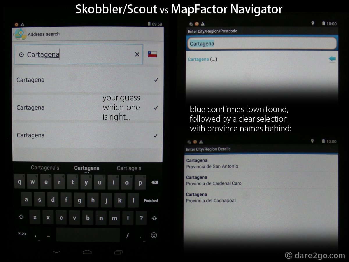
GPS Review: compare search for town names found multiple times
At first glance the Skobbler search screen looks much cleaner – it has a crisp layout with a large readable font size (I don’t even need my reading glasses). But when you type in the name of a small town, the first shortcoming becomes apparent. If there is more than one place in the current country with that name, Skobbler gives you a list to select from. Navigator does too, but with a clear difference: Navigator lists the towns along with the name of the province, so you have some indication which one to choose. With Skobbler you are relying on pure luck; they are not even listed in order of proximity to your current location. (I sometimes think I should go and buy a lottery ticket if I hit the right one first try!) Usually the next step is to ask Skobbler to show the town on the map, zoom way out and try to figure out where it could be. Another thing which really annoys me with Skobbler is that very often, half-way through typing a new address search, it closes down and I have to re-open it.
When I drive secondary roads, I often pick the town centre as the destination, because I normally don’t need a particular street. But in Santiago I usually have a particular address in mind, to either visit people we know or find a specific commercial outlet. When I first switched to Skobbler in Santiago, it was much more precise in its street search than Navigator (read below about Navigator’s search). Now, since its last update in late September or early October, it has somehow “lost” a large number of street names.
Street search using Skobbler in Santiago de Chile had already gone from good to not so good with an update in late July/early August. Now, since the last update, the address search is close to useless!
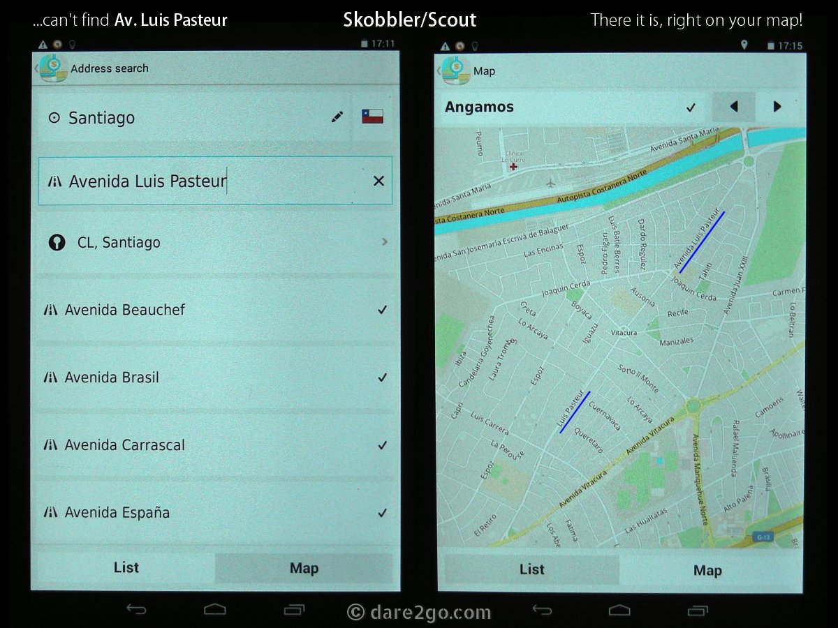
GPS Review: Skobbler failing to find street
For example: our favourite Sushi place, Sakura , has an outlet in Avenida Luis Pasteur 5515, in the suburb of Vitacura (north-east of Santiago Centro). When I wanted to meet Yasha there in September, Skobbler didn’t find the street unless I searched under Vitacura instead of Santiago. But, Navigator found it straight away under Santiago. Now Skobbler doesn’t find it at all, although Avenida Luis Pasteur is a relatively long, main road (see photo)! It doesn’t find it in Santiago and it also doesn’t find Vitacura as a town/place name anymore – NOTHING, NADA, ZILCH! What good is that? The same is happening with many, many other street names or suburbs in greater Santiago. [I only discovered this whilst taking the photos for this review, and then tested it extensively. Please review my EDIT to this at the bottom of this article!]
If the address is in the centre of the city or a main artery road, Skobbler will find the street, and then wants a house number. The data base of house numbers in OSM maps is rather slim, so nowhere near all numbers are included. Skobbler relies on rough guess work as to where a number might be, which can be out by a block or more. With some better programming this shouldn’t really happen, as in Chile the leading digit (or two in the ‘thousands’) refers to the street block, always counting from the end of the street which is closest to the centre of the city. Number 630, for example, will be in the sixth block from that end, 2245 in the twenty-second block.
MapFactor Navigator
Navigator’s address search might not look as pretty as Skobbler’s, but it somehow functions much better (even before Skobbler’s last update – see above). The order remains the same: you start with country, followed by city/town and street name. Then you will notice the first difference – it is also possible to search by cross-roads, which gives a good starting point if the house number search doesn’t yield a result. The house number search is set up differently too; you start typing and Navigator auto-suggests all valid numbers, which will usually place you fairly close to your desired address. Sometimes in cities the size of Santiago it can get complicated, as street names can be repeated, in which case you need to know the suburb. This is also not always helpful, as I know from Berlin that long streets can pass through a number of suburbs and, if you don’t have the suburb name, but only a house number, it can get tricky. The option to search by postcode is available in both apps – if you happen to know it.
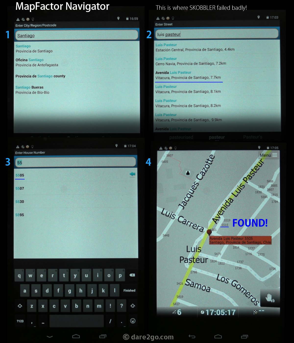
GPS Review: Navigator succeeds to find street and house number
This concludes part 1. Part 2 explains other search options, like POIs and GPS coordinates , and finally Part 3 the routing results and my sometimes scary, occasionally hilarious, but also positive, experiences using these GPS Navigation Apps. My conclusion will be based on all factors – so stay tuned!
EDIT: In the meantime I have given Skobbler a second chance. First I used the program’s menu function, Upgrades > Restore purchases, where it confirmed everything was up-to-date. I still deleted the complete, recently updated, Chile map, re-installed it afresh, and surprise: the address search in Skobbler works again just as it is supposed to! Skobbler, now you have me really fuming (what I really want to write is “pissed off”)! Turns out that now full address search is only available with a data connection! That’s not my understanding of an offline navigation app; address search is the first (and most important) step for a successful navigation! This used to work perfectly well back in May/June/July 2014, why not now?
I consider this nothing short of deceiving advertising. I don’t have a data SIM in my tablet, I never had the intention to, I cross borders way too often for it to be useful to me, many regions I travel don’t have any functioning mobile coverage –

…after I got my refund!
Skobbler GmbH was bought in early 2014 by Telenav and now seems to run under the new name Scout – that’s why I sometimes use both names.
Disclaimer: all links to Amazon are affiliate links; we get a small percentage of your purchase price without it costing you more. Thank you!


We really liked Joost’s blog. Although we have been using OsmAnd+ quite a lot we nevertheless learned some new tricks. Joost is right that OsmAnd+ has many options, but compared with OruxMaps and Locus+ they often are hard to find and some require manipulating of .xml files.
A few examples:
1. I wanted to make the line of the planned route and the driven route thinner, because you can’t see the color of the road and road numbers anymore through it. In our case that lead to a few judgement errors that took a lot of effort in Zimbabwe. In OruxMaps and Locus+ you can just set the color, width and style of the lines in settings. OsmAnd+ requires me to write a render file in .xml
2. I usually create a favorite of every campsite we visit. I want to export the campsites to make the information available to other travelers (see for example http://www.deeindervoorbij.nl/camping.html and http://ioverlander.com/). OruxMaps allows me to just filter and export the favorites I want, in OsmAnd+ I have to manually edit the favourites.gpx file.
3. I have long thought that it is impossible to remove a favorites category, but I recently found out that it can be done.
But all in all OsmAnd+ remains the preferred solution for us for the reasons explained in our blog (http://www.deeindervoorbij.nl/navigation.html).
I see I really have to learn a fair bit more about OsmAnd (and probably my other apps too). So much to do, so little time! Or more precisely: I fear at some stage website maintenance, social media, and navigation apps combined will surpass the real travel experience.
Looking forward to tour next post, especially on Osmand. Yes, rendering is not very fast, though on my LG G2 that isn’t really an issue.
It’s definitely not the most user friendly one, though I don’t understand how De Einder Voorbij can say it has few options. In my opinion it has rather maybe too many options :)
If spamming is allowed: here’s the link again for my tutorial for setting up Osmand for navigating AND contributing to better maps: http://joostschouppe.wordpress.com/2014/07/25/using-osmand-on-the-road/
I should mentioned that the data for the screen capture (in Dutch) on the last page was from Joost’s page linked in his comment. He seems to know much more than I do…
I am going to bookmark this post because I may need it not only traveling outside of my country but in my neighborhood. My father has always joked that I could not be able to find my way out of a paper bag and I’m afraid it’s true. Thank you for that easy to understand instructions.
LOL, wait for part 2 before you decide! Should be up sometime later this week.
Thanks very much for this easy to follow post. Let’s me know once again how much I still have to learn!
I don’t drive when I travel. However, a great post for anyone who does! :)
Both apps can be switched to pedestrian mode to explore places on foot!
This is a really helpful post which I am going to share with my Boomeresque FB followers (probably some overlap with your FB followers ;-) Now for the non-techno person question: Don’t you need some data usage for the app to be able to use your tablet GPS? I have a Nexus 7 also, so this could be very cool. We usually rely on my husband’s Iphone with Google maps because he usually has data access when we travel internationally and I don’t. That saved us quite a bit in Ireland and even in New Mexico where there were some roads with no signs.
No, that’s the beauty of these offline Navigation apps – no data connection required to navigate or search! The only data or WiFi you need is to download maps and updates, but the data (maps and the app) will fit easily onto any tablet or smart phone with sufficient storage (say 8GB minimum or a device with a micro SD-Card slot).
We did extensive comparisons of navigation tools in preparation of and during our trip through Africa. Here is a summary of the results: http://www.deeindervoorbij.nl/navigation.html
Thanks for that. I highly recommend that interested readers follow the link above – no spam! It highlights a number of other options, many I didn’t know about. I installed yesterday the free version of OsmAnd (as mentioned in my previous comment, this app is also mentioned in above article) and ‘played’ a bit with it today. Again differently looking OSM maps, first impression so far is that it renders really slowly as the maps are created in layers; you get the basic grid, which then has, in another layer, colour applied according to importance of roads, then another layer for buildings and POIs, and so on… Makes it rather slow to move around the map as everything gets constantly redrawn.
This was terrific info and explained quite clearly! I’m a bit of a tech geek and love finding apps that will help make our travels smoother and good maps that are near at hand (and readable since our eyes are not as great either!) are always appreciated. I’m going to check if my Kindle Fire has a GPS receiver so that I can download the Navigator – if not I may replace it when we visit the US in April.
I’m still sitting on the fence which one I would really recommend. Overall I still prefer Skobbler for various reasons – more about this in part 2. To complicate things I just installed OsmAnd , another offline navigation app I will evaluate soon.